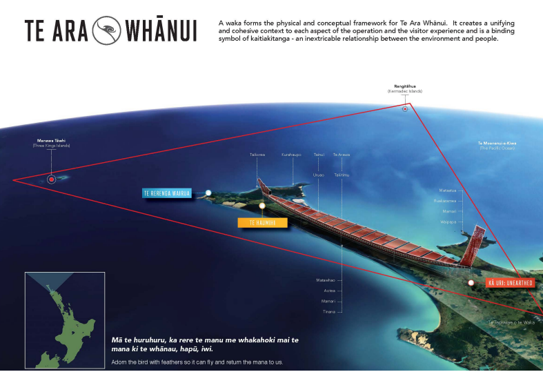
Ngāti Kuri’s contemporary tribal area covers approximately one million square kilometres in the Far North (Te Hiku o Te Ika) and extends from Hukatere on the west coast across to Maunga Tohoraha (Mt Camel) on the east coast and north to Te Rerenga Wairua (Cape Reinga) and Manawatawhi (Three Kings Islands) and Rangitāhua (Kermadec Islands). It is considered a global hotspot of biodiversity.
Te Haumihi figuratively acknowledges our tangible and intangible cultural and natural heritage, and its importance to our identity as Ngāti Kuri. Te Haumihi is Ngati Kuri’s evolving strategic response to Wai262
Our Rohe
Ngāti Kuri’s contemporary tribal area covers approximately one million square kilometres in the Far North (Te Hiku o Te Ika) and extends from Hukatere on the west coast across to Maunga Tohoraha (Mt Camel) on the east coast and north to Te Rerenga Wairua (Cape Reinga) and Manawatawhi (Three Kings Islands) and Rangitāhua (Kermadec Islands). It is considered a global hotspot of biodiversity.
Te Haumihi figuratively acknowledges our tangible and intangible cultural and natural heritage, and its importance to our identity as Ngāti Kuri. Te Haumihi is Ngati Kuri’s evolving strategic response to Wai262
VR Resources
Partnership with NZ Geographic, WWF, Sir Peter Blake Trust & PEW Charitable Trust